

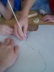
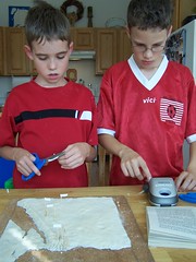
Last week we made a salt dough map of Ancient Egypt. Being a perfectionist, I wanted the shape of the land and water areas to be as accurate as possible. In order to accomplish this, we used an Artograph Tracer Projector which I purchased prior to having children. In order to have the map fit inside the tracing field of the projector, I first had to shrink a blackline map of Ancient Egypt by 50% on my copier/printer. I then used the projector to enlarge the image to the needed size on a piece of plywood that we had lying around in order to trace it. (Sometimes James' pack rat tendencies come in handy! ;-) We also projected the image onto some newsprint to trace the shape of the Nile to use as a pattern.
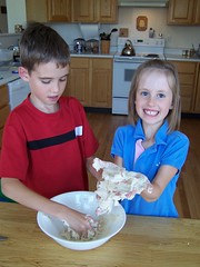
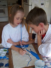
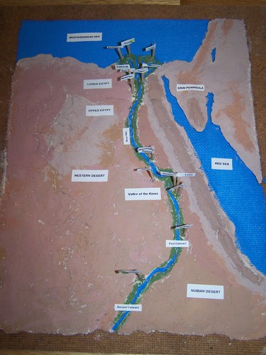
Here is the finished project:
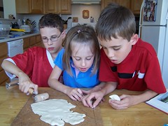
While making the map, I asked the kids to point out the geographical features which protected and isolated Egypt from other ancient cultures. I told them that partly because of Ancient Egypt's unique geography, its culture lasted for thousands of years. We talked about how difficult it would have been to invade Egypt due to the marshy Delta, the dry deserts, the mountains, and the cataracts of the Nile. We talked about the way the Nile brought life to the land. I told the children that the Egyptians thought that they were blessed by the gods because of these features.
God used the land of Egypt to preserve his people at two different times. In the Old Testament, He sent Joseph ahead to prepare Egypt to save Jacob and his sons and their families from famine. They grew in to a great nation in the delta region of the Nile. In the New Testament God sent another Joseph, along with God's own son into Egypt to protect him from bloodthirsty Herod. But both times, He called His people out of Egypt, the land of literal and figurative slavery. When God commanded Pharaoh through Moses to let His people go, He brought about deliverance with plagues that judged the gods of Egypt and brought glory to Himself. Later God called His own Son out of Egypt to save His people from slavery to sin.
In talking about the geography of Egypt, I also briefly contrasted it with the land of Canaan, the Promised Land. As pointed out in a recent sermon at our church, we noted that famine actually often struck that land. Abraham sought relief in Egypt during a time of famine, though his decision and lack of trust in God at that time proved troublesome to his family. Isaac also considered taking shelter in Egypt during a later famine, though God kept him from going that far.
The Promised Land is the "Crossroads of Civilization", a land coveted by many and surrounded by great and threatening nations at all times, but without the same natural protections as the land of Egypt. I told my children that it seemed to me that God used the geography of the Promised Land to force the lesson of trust ~ trust in His promised protection, even in the midst of threatening circumstances! I hope to return to this theme again in our Bible study and further study of ancient times.
And we all enjoyed seeing this blast from the past:

Evan, age six, and his model of the Nile


7 comments:
Congratulations, E, M and S, on your excellent map! I am sure you will never forget the geography of Ancient Egypt! Thanks, Melkhi, for blogging about the whole process. Jan in Dkr
Very, very nice! I've wanted to do a salt dough map, but haven't been brave enough. Thanks for the excellent directions.
Rhonda
That is the coolest map! You & your crew did a fabulous job!! Do you use the Artograph tracer often?
Lee (from the WTM board)
Oh! Look at the tiny Evan! How cute!
Your map looks great! What a fun afternoon!
Hillary in KS
Hi Jan! We hope that your friend's foot is healing and we are rejoicing in your latest news!!!
Rhonda, thanks for the comment. I whined a lot before trying this. :) I like step-by-step instructions and hand-holding the first time we try things, but I just gritted my teeth and started the process. I was so glad that my husband guided the painting.
Lee, I really haven't used the Artograph much, because the tracing field is so small. Now that it has occurred to me to shrink the image before trying to project it, I may use it for other map or poster projects.
Hillary, Giggling about "the tiny Evan" :) It is fun to look back isn't it!
Thats great! What a neat tool too... I will be honest here and say... I had no idea what a Artograph was till today!
Lisa~
Thanks for sharing this. It is a life saver for me as I prepare for our unit 1 of Tapestry of Grace for which we are hoping to make a model of the Nile river.
Post a Comment